First Step
The
Adventure Begins
Day
1 Thur April 5th
By 7:30am and
with a mild 16deg C I
had had a morning shower and was fully packed up and loaded and ready
to go.
In hindsight, although I
had mentioned to
other travellers what I was about to do, more or less in conversation,
I could most probably have generated some media coverage of my
“first step”. As it was at the time, I
was walking out the gate of the caravan park and realised that I should
at least have a photo of “the moment”. But, how to
do it? I hovered, feeling a little ridiculous with the big backpack,
solar panel hanging off the back of the pack and floppy hat on
wondering what kind of photo it should be and how to go about it.
There
was absolutely no activity from the caravaners who have a tendency to
chat into the night and sleep late but after 5 or 10 minutes, I have no
idea how long I was there but I could not consider not recording this
moment somehow. Eventually, a lone walker, a 30 something guy who had
been on a morning walk, came back into the park. I waddled up to him
and “excuse me, I wonder if you would do me a favour? I am
heading off on a walk up through the centre of Australia and I would
like a photo of the occasion.” He readily agreed and I
whipped out the camera and handed it to him. I then recalled thinking
about the walk being from coast to coast, Gulf to Gulf. I asked if he
would walk with me the 250 meters to the shore of Spencer Gulf and take
a couple of shots there as I took my “first step”.
Again he readily agreed and took 3 photos, one of which became the
photo on the home page of the web site. I am sure I asked him his name
but I do not have a record of it. I owe him one because if he did not
turn up just at that time, I probably would have started the walk with
no photographic record of that important, symbolic beginning. These
photos are numbers 96, 97 and 99 in the photo collection.
Photo
numbers refered to are the numbers of the photos in my full DVD photo
collection. 240 of these are displayed in these web pages and there are
2500 altogether. The full DVD collection is available by emailing to

I
walked (strode purposefully, stepped out) for about 1 kilometer and was
passing a Mobil service station where I had had a hot breakfast the
previous morning and thought “What the hell. Why
not.” So I went in, dispensed with the 26kg backpack and sat
down for my last hearty meal for a week. During my 2 cups of coffee I
sent off a group SMS to 21 family and friends to say that I was
officially on the road. I was inundated with return SMSs with
“Good luck”s and many a phone call as well.
In
spite of all this photo taking, walking all of 1 kilometer fully kitted
out and the electronic send off I still felt that I was just
“going for a walk”.
After
consulting my map, which did not have a lot of detail of local streets,
I headed off “in the general direction” of ENE to
pick up the road that goes north from Port Augusta and follows the
railway line running along the Western side of the
Flinders Ranges.
My
intention at this stage was to stop at a corner store and pick up
several pieces of fruit. I find this a good supplement to my meagre
fare but can only carry enough for one day because of the weight. Also,
fruit does not travel well cramped up in the backpack. So I get half a
dozen pieces as I leave civilisation and generally eat it along the way
during the first day. But,,, I found myself on the light industrial
outskirts and no shop. Oh well, I sure wasn’t going back.
There are a maze of small roads going in all directions but I found one
marked “Racecourse Rd” and the racecourse was on my
map so I was going in the right direction. It would not be a good thing
if I got lost trying to get out of town on my first day.
I
called into a nursery/landscape supplies and got instructions or at
least confirmation that the dirt road that I was about to turn onto
(this was the very end of town) was the right one. It was difficult to
ask for instructions as this road did not go anywhere. Well, it went
somewhere, but not to a town. But it was feeding pastoral stations and
eventually I would cross to the eastern side of the Flinders and down
into Hawker. I knew from the map (see map ‘Day
1-3’) that I needed to eventually get to the one that
followed the railway line north. The “target” for
today on the map was “The Ten Mile”, about 15km
away, and I don’t know what was there (nothing as it turned
out) but it was prominent on the map. I chose to take this dirt road to
Hawker as I wanted to avoid the bitumen main road to test out my
equipment (and me). Photo number 100 gives a general idea of the road
surface, the countryside and the ranges in the background. It was for a
distance of about 120km and I figured I could do this in 6 days max and
probably 5 based on past experience from walking 600km from Coolangatta
to Gladstone over a 1 month period.
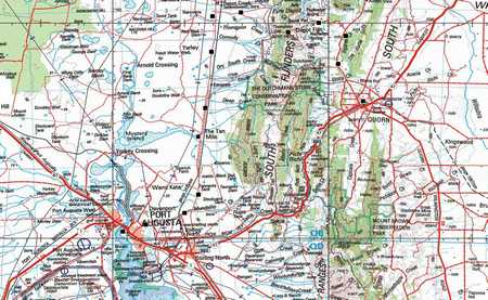
The picture above is a map for
days 1, 2 and 3 into
Quorn,
approximately the same size as the
“day” maps that I carried. The latitude and
longitude lines are on the map with divisions every
‘minute’ which is approximately 2 km. I could find
my position by reading the lat and lon from my GPS and finding this
position on the map.
I had
purchased a CD based set
of maps from the
Gold
Coast Map & Charts shop at the
Harbourtown
shopping complex at
Runaway
Bay on the Gold Coast. The
proprietor, Phil, and I had developed a friendship over several years
as I hounded him for information regarding this walk and previous
outings. I had also purchased one of my GPSs from him. At first I was
looking at “paper” maps but realised fairly quickly
that if I got maps with sufficient detail, they would represent about
50km from the bottom to the top and I would “walk off the
map” in a couple of days. Besides the cost, I would not have
been able to justify the weight. When Phil showed me the
“Australian Government, Geoscience
Natmap
Raster” 4
CD set (and offered me a very generous discount) I was hooked. I spent
hours printing (double sided) and cutting map sections about 20cm X
10cm with the plan being to use them to light the evening fire when I
had “walked off” both the front and back of the
page. Great solution, minimum cost, minimum weight and dual use.
The
road surface was stony but ok underfoot. The rail line was alongside
the road at this time and photo number 101 shows a crossing from this
road to Emeroo homestead several kilometers to the east in the
immediate foothills of the ranges. The photo also shows one of my many
constant companions (Louie) in close-up where I captured him in flight.
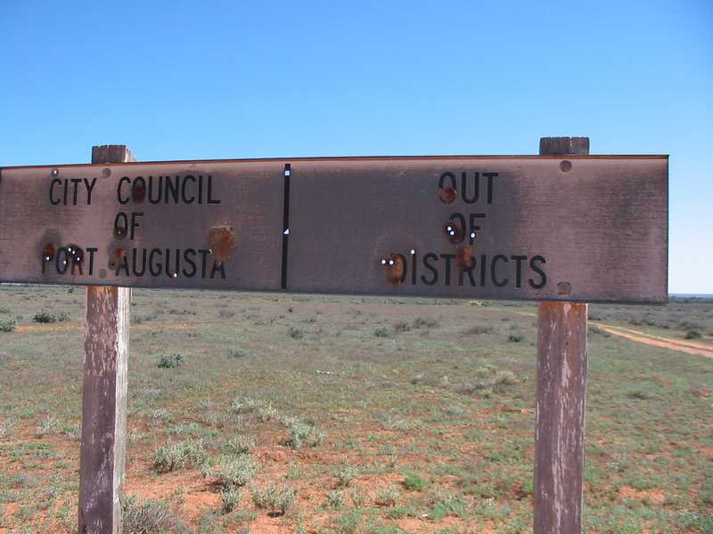
And
not much further on I came to the sign showing where the City of Port
Augusta ended and what the next district was called. Uh oh! Only half a
day on the road and already I have crossed the line into “Out
of Districts”. See photo 102.
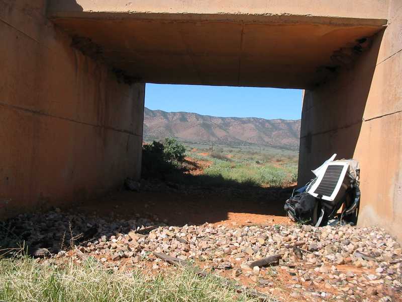
Around 1pm
it was time for a break, as I had been walking for 4 hours or so, not a
cloud in the sky and the temperature was now around 30 degrees. I
searched the horizon for shade but the prospects did not look too good
till I found a culvert under an old railway line so I took a 15 minute
break to rest the legs but mainly the shoulders. Although I abandoned
the idea of a trolley or something similar fairly early in the planning
stages because of the hills and sandy country expected, it sure sounded
like a good idea now. Photo 106 shows the much appreciated shade with
the magnificent view of the Flinders out the “back
door”. Note the solar panel placed to collect as much sun as
possible. Also there are several
fairy
martin nests up in the corner of
the culvert and photo 105 shows a good close-up of these.
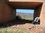
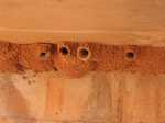
Photo 102
Photo
106
Photo 105
I stopped when I got
to “The Ten Mile” as shown on my map. There was
nothing there of civilisation but it was the first creek I had come to
for a while and looked like a good spot to set up the antenna and the
tent for the night and there was a good supply of firewood. However, I
had only covered 15.5 km from Port Headland (as the crow flies) a
reading taken from the GPS (lat 32:22.914 lon 137:51.327). This was a
total of 20 "road" kilometers so I was not particularly happy with this
although it was a late(ish) start and also I had done no physical
preparation for the walk as I was sure I would get fitter as I went. I
had a long way to go on my rations and I was looking like I would take
longer than planned to get to Hawker, the next town on my route, so I
just had a glass (plastic) of milk, about 600ml. This was made up of 3
tablespoons of powered milk and a tablespoon of
Nestle
Banana Kwik for
flavouring (and it has a bit of extra sugar for energy). This was all I
had since breakfast but I am blessed with a body that does not get
hungry. I love my food and have as much trouble as the next person
keeping my weight under control, but I eat when it is convenient or
when food is in plain view. I consider it a personal victory every time
I pass a
Kentucky Fried
Chicken joint without going in (and
Subway,
Red
Rooster, etc, etc)
The only
traffic on this road so
far today was a motor bike that I saw going north and returning half an
hour later. I was a bit surprised at the small amount of traffic as
part of the safety planning for the walk was to only go where there was
reasonable traffic.
I made camp
and then set up the
antenna and connected the radio. I got good reception and heard several
hams talking but heard nothing from Roger or Bill. And, even though the
solar panel had been connected to the battery pack all day, it only
lasted 10 minutes or so. I was flabbergasted. Had I calculated wrong?
Read on. Tomorrow
I
continue up the
Western side of the Flinders